Look at the following picture and choose the correct option.
A.
b. Antartic circle ; c.Tropic of Capricorn; d. equator; e. Tropic of Capricorn;
B.
a. North Pole; b. Artic circle; f. Antartic circle; g. South Pole
C.
b. Artic circle; c. Tropic of Cancer; e. Tropic of Capricorn; g. Antartic circle
D.
b. Tropic of Cancer; d. Equator; f. Tropic of Capricorn; g. South Pole
2.
It´s the angular measure (from 0° to 90) that locates an exact place from the Equator
A.
Latitude
B.
Longitude
C.
Altitude
D.
Coordinates
3.
This principle establishes the identification and comparison of the events and phenomenon development in space and time, and answers the question "when and where does it happen?"
A.
Location
B.
Casuality
C.
Relation
D.
Generality
4.
These specialized maps are used to locate rivers, towns, cities and communications means.
A.
Geological maps
B.
Urban maps
C.
Topographical maps
D.
Climatological maps
5.
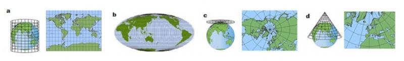
Look at the picture and choose the correct answer that corresponds to each projection.
A.
a. azimuthal ; b. Mollweide ; c. Mercator ; d. Goode Homolosine
B.
a. Mercator ; b. globe; c. Goode Homolosine; d. conic
C.
a. Mercator ; b. Mollweide ; c. azimuthal ; d. conic
D.
a. Goode Homolosine ; b. globe ; c. Mercator ; d. conic
6.
It´s the science used to create maps to geographically represent a place.
A.
Physical geography
B.
Geology
C.
Cartography
D.
Maps
7.
This projection is widely used to create planispheres. Its disadvantage is that it deforms the polar regions. It is the most widely used projection, mainly for maritime navigation.
A.
Mollweide
B.
Mercator
C.
Azimuthal
D.
Conic
8.
It´s the angular measure (from 0° to 180°) that locates any point starting from the Greenwich meridian. Towards the east or the west.
A.
Latitude
B.
Longitude
C.
Altitude
D.
Coordinates
9.
This principle studies the transformation that the geographical events and phenomena undergo. It answers the question "how does the transformation occur? "
A.
Location
B.
Evolution
C.
Relation
D.
Causality
10.
These represent the infrastructure build up by humans such as highways, dams, railroads, etc.